Categories
Central Oregon

Fogarty Creek Kelp Forest

In just the right conditions, the kelp forest at Fogarty Creek is accessible to SCUBA divers from shore.  There are not very many places in Oregon where divers can access kelp forests without a boat.  The surf entrance can be tricky and conditions can change fast but if it you hit the beach at the right time, you can go dive some great kelp beds.  We have not been able to dive this site yet due to unfavorable conditions when we have tried in the past but we have heard of others diving here and from everything we have observed, it looks like a good spot to check out when the seas are kind and calm.


Site Highlights:

The main draw here is the kelp beds just off shore from Fogarty Creek.  There are some interesting rock formations to check out, too.  Someday otters will once again live here but for now, it will only be us SCUBA divers and a few other mammals visiting these kelp beds.

Nearest Town:

Lincoln Beach is just north of Fogarty Creek and just to the south is Depoe Bay.

GPS Coordinates:

44.839318, -124.051719


Special Directions to Site:

Watch for the Fogarty Creek State Recreation Area signs on US101 north of Depoe Bay.

Parking:

There is plenty of parking at the state rec area.  You will probably have to pay to park here but double-check the signs.
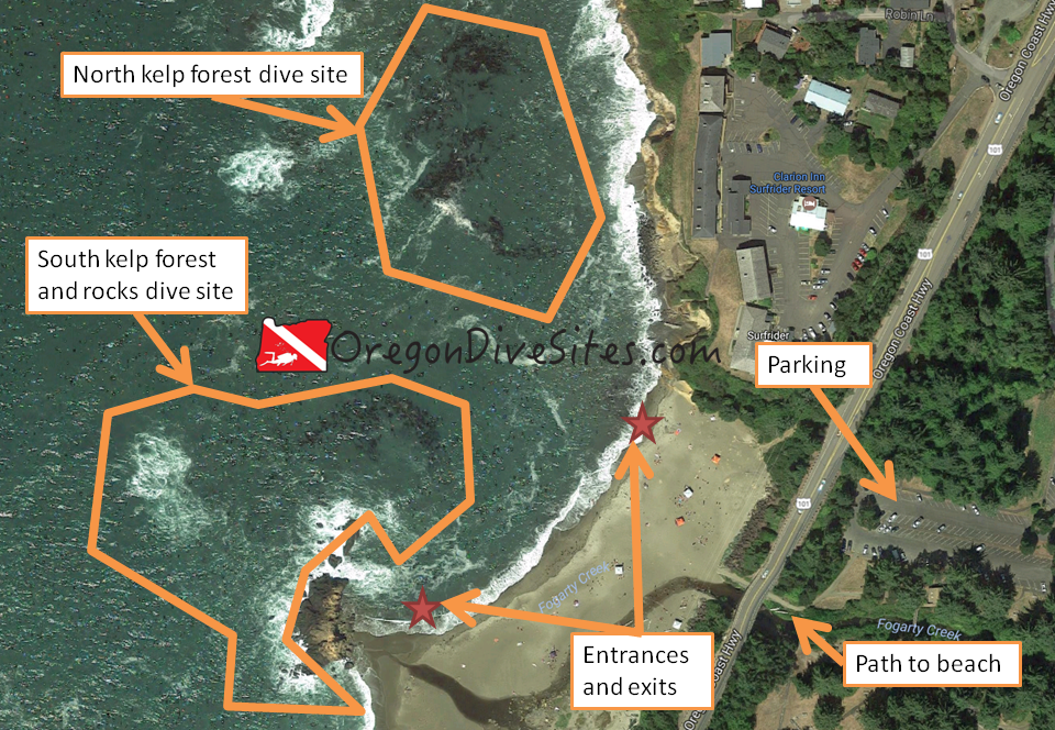
fogarty creek kelp forest
Imagery ©2017 Google, Map data ©2017 Google.
The kelp forest at Fogarty Creek is shore-accessible in calm sea conditions.


Site Orientation:

The kelp forest is split into two parts.  The northern kelp forest is larger but a bit more of a surface swim to get to.  The southern kelp forest is smaller and a shorter swim.  There are some interesting rock formations near the southern kelp forest that can also be visited.

One thing to remember here is that surf conditions need to be really good before you try diving at Fogarty Creek.  There aren’t many beach surf entrances in Oregon and it is important to know how to do safe entrances and exits from the beach.  We’re not your mom so make sure you know what you’re doing.

Entrances and Exits:

You can enter or exit just about anywhere along the beach but doing your entrance/exit nearer to the area you want to dive is a good idea.  However, you need to do an entrance and an exit where it is safe to do so.  Surf conditions, current, undertow, and other conditions will dictate where it is best to enter/exit.  If you don’t know how to do an army crawl out of the water, you should get instruction on how to do so.

Salt/Fresh:

This is a salt water dive.

Shore/Boat:

This is a shore dive although you can also access the site from a boat.  If you wanted to, you could probably put in an inflatable raft with an engine here.  We have not done this yet so be sure to double-check with the relevant state authorities before launching a boat from Fogarty Creek Beach.

Normal Conditions:

Normally the conditions are rotten here.  Surf, surge, current, waves, undertow, and many other bad and nasty things are the norm here.  On a rare calm day, you will have better conditions but there are still dangers here.

Normal Visibility:

Viz can be up to 30 feet here.  Sometimes it’s even better.  The summer upwelling can reduce visibility and right after a storm there will be worse viz.

Normal Temperature:

Depending on the time of year, you will see temperatures between 45 and 55F.

Best Time of Year:

There isn’t really a good time of year to dive here but in the summer and early fall, you have a better shot of having halfway decent conditions to dive Fogarty Creek Kelp Forest.

Max Depth:

This is a fairly shallow site which makes surge much worse here than other deeper kelp beds in Oregon.  You can find 30 feet on the far west side of the kelp beds.

Suggested Special Training:

Advanced open water training is a really good idea before diving this site.  Rescue diver training is a good idea.  Lots of practice and training in surf entrances and exits is needed here.

Difficulty of Dive:

This is an advanced dive.  You need to know what you’re doing before you do a shore dive into the open ocean.  Even people with many dives on the Oregon coast can make mistakes here that can lead to being killed or even worse.  Be sure you know what you’re doing and you’re comfortable with the conditions before you go diving.

Distance of Walk to Entrance:

You will have between 500 and 1000 feet to walk to get to the entrance.

Surface Swim Length:

A surface swim between 100 and 200 feet is a good idea to get into some deeper water.

Special Site Notes:

This site is dangerous in all but the best conditions.  In even ideal conditions, the site is still dangerous.  Take a safety sausage.  Have a friend keep track of you from the surface.  Be sure you have plenty of air in your tank in case you have to belly crawl out of the surf.

Closest Local Dive Shops to Get Air Fills and SCUBA Gear:

There is an air fill station in Depoe Bay that you can get air at by appointment only.  Otherwise you’ll need to go up to Astoria or in to Portland, Salem, or Eugene for a full service SCUBA shop.

Nearby Restaurants We Like:

There is lots of good food on this part of the coast.  Let us know what your favorite place is!

Nearby Places to Camp and Diver-Friendly Hotels:

There are several state campgrounds in the area as well as many hotels and vacation rentals.  We haven’t tried any of the lodging outside of tent camping around here so please let us know if you have found a good hotel or house that welcomes divers.

What Other People Have to Say About This Site:

Please write in the comments below your experiences with this dive site!
Categories
Central Oregon

Lower Deschutes Boat Ramp at Lake Billy Chinook

The lower Deschutes boat ramp on Lake Billy Chinook is a good place to go diving in Central Oregon.  You can go very deep here if you want or you can stay more shallow to check out the underwater cliff faces, the underwater rock formations, and search for things lost by boaters.

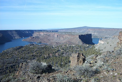
Cove Palisades SP Oregon 2002.03.31
The lower Deschutes boat ramp at Cove Palisades State Park is on the west side of the “Island” in the middle of this picture. Ipoellet at the English language Wikipedia [GFDL or CC-BY-SA-3.0], via Wikimedia Commons

Site Highlights:

The lower Deschutes boat ramp is an exciting place to dive because of the underwater cliffs and rock formations.  Much like some of the other sites on Lake Billy Chinook, this site has a variety of terrain from relatively shallow sandy areas near the roped-off swimming spots to sheer vertical underwater cliffs.  You can often find things that fell off boats around the boat ramp and other random odds and ends that went overboard in the general dive site area.

Nearest Town:

There are a few small towns nearby including Culver, Metolius, and Madras.  To the south, Bend and Redmond have some dive shops.

GPS Coordinates:

44.547443, -121.279279

Special Directions to Site:

There are signs on US 97 for Cove Palisades State Park.  Follow them through a series of roads until you descend down into the canyon.  Look for signs for the lower Deschutes boat ramp once you’ve crossed the bridge over the Crooked River finger of the lake.

Parking:

There is usually ample parking although on busy summer weekends, it can be completely full.  The last time we were here, we had to pay a day use fee to park.  Your Oregon State Parks Pass might work here but double-check when you go to park to see what you need to do.  You can drop your gear off down by the boat ramp after you have your equipment setup and then go park in the car parking area.  If it’s a quiet day with not many boat trailers, you can usually get away with leaving your car in the boat trailer parking.


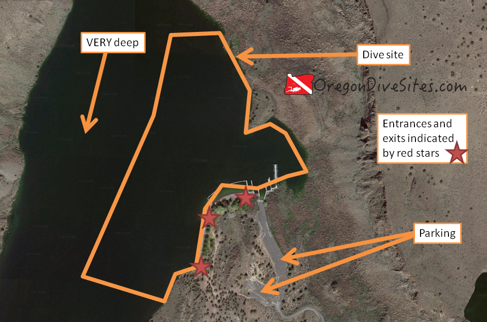
Imagery ©2017 Google, Map data ©2017 Google.
The lower Deschutes boat ramp is a good place to dive in Lake Billy Chinook. The underwater terrain is varied and you can go very deep if you want or you can stay shallower in a few areas.

Site Orientation:

This site runs more or less north-south.  There is a little bay in the middle of the site that heads east and is where the boat ramp is located.  The little bay and the area around the roped off swimming spot are the shallowest and gentlest places to dive.  If you go further west, north, or south, things get deep very quickly and also very steep.  There are some vertical underwater cliffs as well.  If you head west and don’t watch your gauges, you can go beyond recreational scuba depth limits so pay attention!

Entrances and Exits:

If there isn’t much boat traffic, you can hop in at the boat ramp.  Otherwise, the swimming beach is an easy entrance with a nice and sandy spot to walk in.  To the west and south, there are a couple swim ladders you can climb in on from the wall where boats sometimes tie up.

Salt/Fresh:

This is a fresh water dive.

Shore/Boat:

We have done this as a shore dive but you can also do boat diving here.  If you’re spending a long weekend on Lake Billy Chinook with your pontoon boat, this is a good dive site to check out your gear and practice your boat entrances and exits before motoring out into other parts of the lake.

Normal Conditions:

Usually there isn’t much current unless you get deep enough and usually there aren’t many naturally occurring waves.  There can be waves and wake from boats passing by though.  This lake is very popular with many different types of boaters so it’s important to fly a dive flag, even if you’re diving from a boat.

Normal Visibility:

Except in the swimming area and right around the boat ramp, visibility is usually pretty good with viz often being 40-60 feet or better.  Where the water gets stirred up, it can be quite a bit lower.  The bottom doesn’t have much to stir up.

Normal Temperature:

The deeper you go, the colder it usually gets at the lower Deschutes boat ramp.  On the surface in late summer, we’ve seen in the 70s at this SCUBA site while at depth it can still be in the low 40s.

Best Time of Year:

This site is diveable any time of the year although we prefer summer and fall.

Max Depth:

We’ve gone down as far as 80 feet here but you can exceed the maximum recreational SCUBA depth limits if you aren’t careful.

Suggested Special Training:

This is an altitude diving site.  We suggest having at least advanced open water training because of the potential to go very deep very quickly.

Difficulty of Dive:

We rate this as an intermediate dive because of the depth.

Distance of Walk to Entrance:

Depending on how close you can get your car, you may have to walk only a few feet or a couple thousand feet.

Surface Swim Length:

No surface swim is necessary at the lower Deschutes boat ramp.

Special Site Notes:

This site has a lot of boat traffic during high season (summer and fall).  Fly a dive flag!

Closest Local Dive Shops to Get Air Fills and SCUBA Gear:

There are a few SCUBA shops in Bend that offer full service.

Nearby Restaurants We Like:

We haven’t tried any of the restaurants right by the lake so please let us know if you have a favorite.

Nearby Places to Camp and Diver-Friendly Hotels:

There are several state and federal-run campsites in the area as well as a private resort with cabins for rent.

What Other People Have to Say About This Site:

Please write in the comments below your experiences with this dive site!
Categories
Central Oregon

Lake Billy Chinook – The Cove Palisades State Park – Upper Deschutes Boat Launch

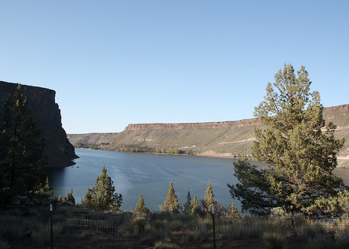
The Upper Deschutes Boat Launch at Lake Billy Chinook is a fun place to go diving in central Oregon.  There are some interesting underwater rock formations along the submerged cliff walls but the site also has good areas for shallower diving depending on what you’re looking for in a SCUBA adventure.

029_view_odfw
Lake BIlly Chinook. Photo by the Oregon Department of Fish and Wildlife. Copyright 2009.

Site Highlights:

We like this site for the interesting submerged cliffs and underwater rock formations.  There are also some good areas to practice SCUBA skills near the shore.  Diving in Lake Billy Chinook is not something most people from the west side of the Cascades would usually but it is worth the drive to Central Oregon to test the waters.

Nearest Town:

The nearest large town is Bend with Redmond in between.  Culver and Metolius are both closer although they are smaller towns.

GPS Coordinates:

44.532684, -121.291513

Special Directions to Site:

Follow the signs to The Cove Palisades State Park and then look for the turn-off for the Upper Descutes Boat Launch and Day Use Area.

Parking:

There is ample parking at this site.  The last time we were here, we did need to pay for parking although this may change based on the time of year.  There are two parking areas to choose from.  One is designated for boat trailer parking and the other is for car parking.  The Upper Deschutes Boat Launch is right by the trailer parking while the day use area is by the car parking.

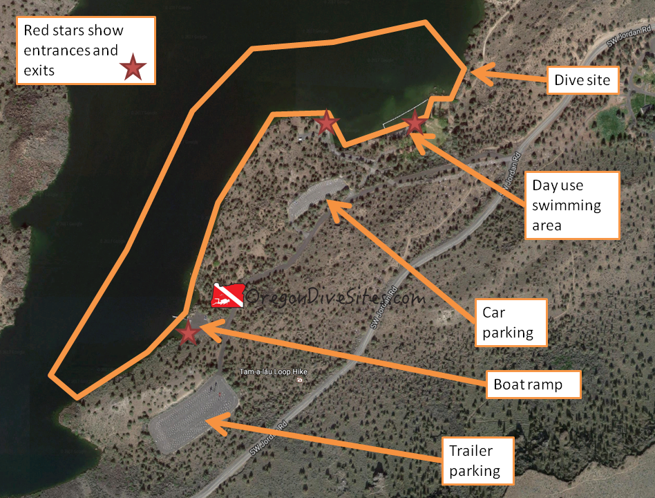
deschutes upper boat launch
Imagery ©2017 Google, Map data ©2017 Google.
The Deschutes upper boat launch and day use area is a big dive site that could be explored across multiple dives.


Site Orientation:

The Deschutes Upper Boat Launch and day use area could be considered two sites.  Certainly there is enough underwater ground to cover that the site merits at least two dives.  On the southwest side of the dive site where the boat launch is located, the submerged cliffs fall away rapidly from the bank.  At the northeastern part of this dive site, SCUBA divers will find a more gently sloping bottom around the roped off swimming area.

We found this site to be the most fun by starting at the southwest entrance and swimming along the submerged canyon walls until we came out at the northeast exit.  Swimming the opposite way you may encounter a very gentle current from the Deschutes River.

Entrances and Exits:

The three easiest places to enter and exit are at the boat ramp (one entrance/exit) and by the day use swimming area (two entrances/exits).  Around the boat ramp, be sure to watch for boat traffic and give way to other users of the upper Deschutes boat launch area.

Salt/Fresh:

This is a fresh water dive.

Shore/Boat:

This is a shore dive although we have SCUBA buddies who have done this as a boat dive.

Normal Conditions:

There can be some waves from boat wakes but otherwise conditions are usually pretty mild at the upper Deschutes boat launch.  Water level in the lake can vary throughout the year so be prepared for low or high water.  Depending on when you go, the amount of boat traffic at the boat launch might be too great for you to safely enter or exit the water there.

Normal Visibility:

Visibility is usually in the 20-30 foot range except around the swimming area where it can be much less when swimmers stir up the bottom.

Normal Temperature:

Temperature varies throughout the year based on snow melt feeding into the reservoir and how much energy the sun has pumped into the lake.  We have found a surface thermocline at this site of 60F and deeper water temperatures of 40F.

Best Time of Year:

We like diving this site in the early fall after most of the weekend boat traffic has left the lake and before snow starts falling in the Cascades.  However, the site is accessible most of the year (although sometimes parking is not).

Max Depth:

We never went past 75 feet here but you can go much deeper if you head out toward the old Deschutes river bed at the bottom of the flooded canyon.  Watch your depth gauge and remember that this is an altitude dive.

Suggested Special Training:

Open water divers with experience diving walls can do this site.  However, this is an altitude dive so you should have altitude diver training.

Difficulty of Dive:

We rate this as an intermediate dive for a few different reasons.  First, the boat traffic in the area makes it more challenging to stay safe.  Second, the underwater rock walls that you will be diving along can be tricky to dive if you haven’t had that experience before because you can easily go too deep or accidentally surface.  Third, this is an altitude dive and requires altitude diver training.  Fourth, the walks to entrances and exits can potentially be very long.

Distance of Walk to Entrance:

Depending on the time of year and how much boat traffic there is at the upper Deschutes boat launch, you may be walking from a long way away.  Expect at least a 200 foot walk from the closest parking to the boat ramp and plan for possibly 800 feet of walking.  One approach is to assemble your gear in one of the parking areas, drive it as close as possible to the entrance you want to use, drop your gear off, go park, walk back, don your gear, and enter the water.  Upon surfacing, doff your gear where you can pull up a car, go walk to your car and bring it to your gear, load up your gear, and take it somewhere else to break down.

The lengthy walks convince some people to dive this site using a boat.

Surface Swim Length:

No surface swim is needed here.

Special Site Notes:

Be mindful of boaters using the boat ramp.  We always give boaters priority when we use a boat ramp as an entrance or exit.  Several times at different boat ramps across Oregon, we have made friends by helping boaters recover lost equipment that took a swim after falling overboard at the ramp.

Because of all of the boat traffic in this area, it is a very good idea to have a dive flag and use it.  We have a dive flag that we highly recommend on our Gear We Use page.

Remember that this is an altitude diving site and you should have training to dive at altitude.

It is easy to go too deep at this site.  Watch your depth gauges carefully.

[Underwater Map of Dive Site Coming Soon!]

Closest Local Dive Shops to Get Air Fills and SCUBA Gear:

There is a dive shop in Bend that does air fills, services gear, and has gear for sale.

Nearby Restaurants We Like:

We haven’t tried any of the restaurants in the area although we know there are some places to eat in the nearby towns.  Please let us know if you have a favorite place to get food!

Nearby Places to Camp and Diver-Friendly Hotels:

There are some state and federal campgrounds in the area, and over on the Crooked River branch of Lake Billy Chinook there is a resort with cabins for rent.  Please let us know if you have a favorite place to camp around the upper Deschutes boat launch that is SCUBA friendly!

What Other People Have to Say About This Site:

Please write in the comments below your experiences with this dive site!
Categories
Central Oregon

Lake Billy Chinook – The Cove Palisades State Park – Crooked River Boat Ramp

The Crooked River Boat Ramp at Lake Billy Chinook is a good place to go get wet in Central Oregon.  You can either do this as a shore dive or a boat dive depending on if you bring a pontoon or motorboat with you.  The site varies from a fairly shallow and sandy bottom to deep, steep, and rocky.  There is a fair amount of boat traffic in the summer around the boat ramp but there are plenty of other places to enter and exit the water nearby for shore diving.  We have had a good time searching for objects lost by boaters at the boat ramp.  More often than not, it seems that there is a boater with something that just fell overboard who is very happy to see a couple SCUBA divers in the parking lot.

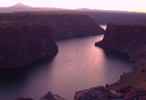
Lake Billy Chinook and Mt. Jefferson
Copyright 2009 Sarah McDevitt. Lake Billy Chinook has a lot of potential for SCUBA diving if you have a boat. The Crooked River Boat Ramp is a good place to put your boat in or to shore dive.

Site Highlights:

The draw for us to dive around the Crooked River Boat Ramp is the underwater topography.  While the swimming area and directly around it are relatively shallow and sandy, going to either the north or south you will encounter steep underwater cliffs that are fun to explore.  Taking a boat farther out into the lake opens up many potential dive sites that we haven’t been able to explore yet.

Nearest Town:

Culver and Metolius, Oregon are the two closest small towns.  Redmond and Bend are further south and have more services.

GPS Coordinates:

44.554023, -121.262217

Special Directions to Site:

From US 97, follow signs for Lake Billy Chinook and The Cove Palisades State Park.  You’ll end up on SW Jordan Road as you descend into the canyon.  Right after the switchback at the bottom, the marina is on the right and clearly signed as the Crooked River Boat Ramp.

Parking:

Parking is plentiful although it fills up on weekends in the summer.  Be sure to park in the lot that is appropriate for your vehicle.  Don’t take up a boat trailer spot with your car.  The last time we were here, we paid to park but that may have changed.

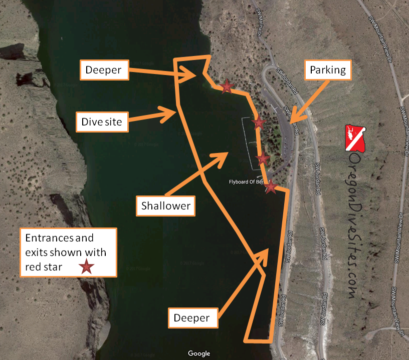
Imagery ©2017 Google, Map data ©2017 Google. The Crooked River Boat Ramp has a lot of good entrances and exits, and varied terrain that keeps this dive site interesting.


Site Orientation:

The site runs roughly north-south.  The further to the west you go, the deeper it gets.  We haven’t gone beyond 75 feet deep at this site although the depth finder on our boat indicated that out in the old river channel, you can surpass the maximum recreational SCUBA diver depth limit.

Around the boat ramp and swimming area, the bottom is mostly flat and sandy.  This is a shallower area that is appropriate for practicing your SCUBA skills.  To the north and south, the water gets deeper and the terrain gets more rugged and rocky.  We have found big boulders underwater that must have plunged down centuries ago from the basalt cap rocks on the mesas high above.

Be sure to steer clear of the boat ramp and docks when boaters are present unless you’re helping a boater retrieve lost gear.

Entrances and Exits:

There is an entrance and an exit for everyone here.  Most of the entrances are easy walk-ins.  A few you have to do some big steps down to the water.  At the boat ramp, someone with limited ability can walk right into the water.

Salt/Fresh:

This is a fresh water dive.

Shore/Boat:

The Crooked River Boat Ramp can be dived as a shore dive or a boat dive depending on what you want to do.  If you’re doing a boat dive, we suggest you head further north along the lake and check out some of the cliffs up in that direction.  The entire lake is diveable although you need to check with local regulations to see if SCUBA divers are allowed everywhere.

Normal Conditions:

You sometimes can get a little wake from boaters coming into the marina too fast.  Otherwise, there can be a little current to the west of this dive site if the Crooked River is running high during the spring snow melt.  Beyond that, this is a pretty benign dive site compared to diving on the Oregon coast.

Normal Visibility:

The last time we went diving here, we easily had 50 feet of visibility although during the end of the summer when water quality can be very poor, the viz can go much lower.

Normal Temperature:

We have seen water temperatures as cold as 38F at depth and as warm as 60F in the shallows here.

Best Time of Year:

In the summer, the lake is packed with boats which makes it a little more tricky to dive around the Crooked River Boat Ramp.  However, the air and water are warmer and all of the concessions along the lake are open.

In the winter, we have heard that the gate to this site sometimes is closed although we have not had that problem ourselves.

This site is diveable all year round.  Choose your favorite time of year to go to Central Oregon and head to Lake Billy Chinook!

Max Depth:

We haven’t gone past 75 feet at this site although you should be able to touch 130 feet without too much effort to the west of the site.

Suggested Special Training:

Open water divers can dive this site after taking an altitude specialty class.  The lake elevation is usually around 1900 feet above sea level making this an altitude dive.

Difficulty of Dive:

This is an easy dive site that can be enjoyed by everyone assuming that you have altitude diver training.  Entrances and exits are very easy.  There is even handicapped parking right next to the boat ramp.  If you want a little more challenge, go either north or south along the canyon walls to find underwater cliffs and deep water.

Distance of Walk to Entrance:

Depending on where you park, it can be between a 50 foot and a 500 foot walk to the entrance.

Surface Swim Length:

If you enter in the swimming area, you’ll want to kick out 100 feet or so in order to find some deeper water.  Otherwise the other entrances don’t require much of a surface swim.

Special Site Notes:

Steer clear of the boat ramp if boaters are actively putting in or taking out boats.  We suggest flying a dive flag to let boaters know where you are.  We have one we use all the time when we go diving in Oregon that we highly recommend.  Check out our Gear We Use page for details.

[Underwater Map of Dive Site Coming Soon!]

Closest Local Dive Shops to Get Air Fills and SCUBA Gear:

There is a full service SCUBA shop in Bend.

Nearby Restaurants We Like:

There are a few restaurants in Culver and more up north on US 97 in Madras.  If you have a favorite, please let us know!

Nearby Places to Camp and Diver-Friendly Hotels:

There are several state and federal-run campgrounds nearby.  There is also a private resort just down the road with cabins.  If you know of any hotels in the area that are SCUBA diver friendly, please let us know!

What Other People Have to Say About This Site:

Please write in the comments below your experiences with this dive site!