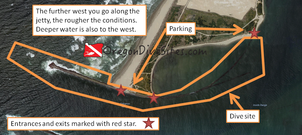
The Coos Bay north jetty is a bit difficult to access but is worth the drive. There are places for freshly certified open water divers to dive and for battle hardened veteran divers to have a challenging day. The inside eastern side of the dive site curls around along a partially-submerged jetty structure and provides generally tranquil waters for diving in almost any weather conditions. The outer western part of the dive site is fully exposed to the wrath of the Pacific Ocean and is only diveable in favorable sea conditions. Off the tip of the above-water part of the jetty, a long submerged part of the jetty keeps heading west. Sometimes you can find interesting debris among those western rocks. If you have the training, doing a drift dive here can be pretty fun.

Site Highlights:
This site has a little of everything. You can do an awesome drift dive here, riding the current in from the western part of the jetty to the northeastern part. You can do some great spearfishing and crabbing anywhere along the jetty. You can explore the sunken part of the western jetty looking for forgotten relics of wrecked ships. You can practice your SCUBA skills in the protected waters on the north side of the inner part of the jetty. You can hone your navigational skills in the triangle-shaped area of the inner jetty to see if you can successfully traverse between the two tips of the inner jetty. There is a lot going for this dive site and it really warrants multiple dives to explore each part of the site. The site is too big to fully cover except if you’re doing a drift dive. And even then, it’s still pretty big.
Nearest Town:
If you were to swim due south from this dive site, you would run into Charleston, Oregon. However, you’ll be coming from the north along the sand spit to get here. In that case, the towns of Glasgow, North Bend, Empire, and Coos Bay are what you’ll come across first.
GPS Coordinates:
Special Directions to Site:
Access to this area is via some sand roads across the sand spit. From US101 just north of the Coos Bay Bridge, turn onto Trans Pacific Lane. Follow the road until you get to the Southport Lumber Mill. Just before the mill, turn right onto the sand road (it is called South Dike Road but sometimes the sign is missing). Keep going until you’re almost on the beach and then turn left (sometimes this is signed as Foredune Road). Follow along this road south past the FAA tower and the former home of the wreck of the New Carissa. As you get toward the bottom of the sand spit, there is a road that cuts back into the dunes. This goes to the northeast side of the dive site. The road that keeps heading south ends up on the western part of the dive site.
Since this is all sand, you need to be prepared to drive in the sand. If you get stuck, the tow bill will be very large.
Parking:
This is a BLM site. Check with the BLM to see what permits you need. We think that you need to have an Oregon OHV permit for your street legal vehicle these days. Note that the whole area is closed to vehicles from mid-March to mid-September. Be sure to check locally before driving onto the sand.
Site Orientation:
The outer (western) part of the dive site along the Coos Bay north jetty heads mostly west. The jetty dives under the waves as it heads further west. The rubble on the bottom sometimes holds little secrets to be found.
As you move into Coos Bay, the jetty curls up to the north. On the western side of the curved part of the jetty there is a fairly calm pool that is a good bet to go diving in rough sea conditions. It’s shallower here but you might find some crabs along this part of the jetty.
On the south side of the jetty between the middle of the site and the north prat of the dive site, the site slowly gets shallower. Around the area where the jetty splits into two, there are a few scattered underwater ruins to discover.
Entrances and Exits:
The entrances on the north east side of the Coos Bay north jetty are much easier to get in and out of the water. Toward the west side of the dive site, you will be scrambling over jetty rocks.
Salt/Fresh:
This is a salt water dive.
Shore/Boat:
This is a shore dive.
Normal Conditions:
In the protected area to the west of the Coos Bay north jetty where it curls to the north, you will usually have fairly calm water. Out in the river channel, you will almost certainly encounter current. As you head further west along the jetty, conditions will get progressively rougher with surf, surge, waves, and current almost certainly waiting for you.
Normal Visibility:
Depending on ocean and river conditions, you may encounter 5 feet of viz or up to 25 feet of visibility.
Normal Temperature:
Except in the shallow protected area behind the Coos Bay north jetty where water can get up into the low 60s in the summer, the rest of the site ranges from 45 to 55F.
Best Time of Year:
Most of the dunes and sand roads are closed between mid March and mid September. Unless you walk in on foot or take a boat in, it’s best to wait to dive this site when there aren’t seasonal closures due to nesting seabirds.
Max Depth:
Depth varies widely at this site. At the far western tip of the Coos Bay north jetty, you’ll hit 50 feet. Heading inland, the bottom rises up to be about 20 feet deep where the rocks come out of the water. Near where the jetty and sand meet, you will find the bottom at around 40 feet. Further up into Coos Bay, the water gets shallower. On the northwest side of the Coos Bay north jetty in the protected area, water can be very shallow.
Suggested Special Training:
If you stay in the protected area, a freshly certified open water diver is capable of diving this site. If you head out toward the tip jetty, you need to be an experienced diver. For drift diving, you should have experience with it already and the proper training. Conditions out on the jetty tip are almost always lousy so be prepared.
Difficulty of Dive:
We rate this as an intermediate dive although the western tip of the Coos Bay north jetty is usually an extremely advanced dive due to rough ocean conditions (if it’s diveable at all). The protected area is a beginner dive. The parts in between are more in the intermediate range.
Distance of Walk to Entrance:
Depending on where you drive and park, you might have a 50 foot walk or a multi mile walk. Just be careful with driving in the sand. Make sure you know how to drive in it and be ready to self-recover.
Surface Swim Length:
There isn’t any need for a surface swim here.
Special Site Notes:
Remember that road access is closed mid-March through mid-September. When the weather is rough, we don’t recommend going out on the western tip of the jetty.
Closest Local Dive Shops to Get Air Fills and SCUBA Gear:
There used to be a dive shop in Coos Bay but it appears to have closed recently. Down in Port Orford there is an air fill station at the harbor. Up in Depoe Bay there might still be an air fill station available by appointment. Otherwise you need to head inland toward Eugene or Grants Pass where there are full service SCUBA shops.
Nearby Restaurants We Like:
There is a lot of good food around Coos Bay. You have to drive a ways from the dive site to get it but it’s worth it.
Nearby Places to Camp and Diver-Friendly Hotels:
We’ve never stayed overnight in Coos Bay so we can’t give any recommendations. If you have some, please let us know!
What Other People Have to Say About This Site:
Please write in the comments below your experiences with this dive site!
